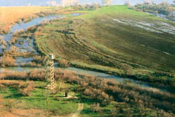
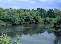
At the northeastern corner of Greece and nearly 20-km from Alexandroupolis at the crossroad between East and West, North and South, the river Evros is forming an ecosystem of international importance, according to the Ramsar contract, known as the Evros delta. Evros is one of the biggest rivers in the Balkans with its 430-km length, from which the 203-km are forming the natural borderline between Greece and Turkey.
According to Ploutarchos, the initial name of the river was Romvos. Today the river is called Evros. Evros was the son of the Thracian king named Kassandros this is from where the river has its name. Evros was slandered from his stepmother, Damasipi, because he refused her love.
 After that Evros was chased from his father because he believed Damasipi, Evros was so disappointed and jumped into the river, since then the river is carrying his name. The story of the despaired purity, which is hunted and is trying to survive in our nature, after this entire story is familiar thanks to the myth of Hypolytos.
The archimandrite N. Vafiadis is telling us another name of the river, he is naming it Maritsa, according to his theory the name might comes from the ancient Thracian name Marissos or Maris, the Thracians used to call the rivers with this name because of the shimmering of the surfaces, or from the Slavic name Moritsi or Moravitsi or from the Indo- European word mar, which means lake or sea.
The sources of the river are located on Skomio, a mountain that is close to Sofia. The river is flowing to the southeast and is entering Greece, a small part of it, from Ormenio until a village called Dilofo, is forming the natural borderline between Greece and Bulgaria. From this region on and until the village Marasia, where the river is entering Turkey and from the village Nea Vissa until the rivers’ outfall it is forming the natural borderline between Greece and Turkey.
 The tributaries of Evros are Ardas, Erithropotamos and Erginis. The river Evros is flowing into the Aegean Sea and at its coast it is forming an extended Delta. The are of the delta is covering 188.000 sq.meters, from which 150.000 sq.meters belong to Greece. From those, 100.000 sq.meters are forming the area that is included in the Ramsar contract. The are is considered as one of the most important hydrotopes worldwide.
The valley of the river is formed from several ecosystems that expand from Nea Vissa until the sea, here you can find a large variety of biotopes with a rich flora and fauna, which was created from the aquatic systems of the river and its tributaries and from the eastern endings of the Rodopi mountain range. At the southern part of this valley, there where the river is branching, the delta is forming.
The delta of the river was formed 10.000 years ago, the melting of the glaciers had as result the rising of the sea-level. After that the sea literally drowned the north Aegean coast and inundating the low land of the delta. This alteration reduced the grade and the flowing speed of the river the result of this phenomenon was the change of the rivers “behavior”.
Many times the river was flowing over its main riverbed and created new ones, it left materials behind during its flowing and also when the waters reached its outfall. Simultaneously the wave and current activities of the sea were increasing in the coastal area of the delta, as a result of these activities were the dispersion of the material in this area.In the summertime when the river waters are reducing, the seawaters, because of the small hypsometric difference from the sea level and the calmly flowing of the river waters, are insinuating the riverbed and the artificial canals.
The result of these natural activities is the forming of various coasts, small islands, lagoons, swamps, dunes and many other small biotopes in the coastal area of the delta, all these facts are characterizing a developing ecosystem.
In the winter sometimes the river is flowing over its bed forming smaller or bigger aquatic areas by inundating the southeastern part of the delta. At the Turkish side is the Gala lake our ancient forefathers used to call the lake Stendoritida, while at the Greek side you can see the lake of the water nymph and several other smaller lakes, such as the Tsekouri, Skepi, Spitia and Gyneka lakes.
According to Ploutarchos, the initial name of the river was Romvos. Today the river is called Evros. Evros was the son of the Thracian king named Kassandros this is from where the river has its name. Evros was slandered from his stepmother, Damasipi, because he refused her love.
 After that Evros was chased from his father because he believed Damasipi, Evros was so disappointed and jumped into the river, since then the river is carrying his name. The story of the despaired purity, which is hunted and is trying to survive in our nature, after this entire story is familiar thanks to the myth of Hypolytos.
The archimandrite N. Vafiadis is telling us another name of the river, he is naming it Maritsa, according to his theory the name might comes from the ancient Thracian name Marissos or Maris, the Thracians used to call the rivers with this name because of the shimmering of the surfaces, or from the Slavic name Moritsi or Moravitsi or from the Indo- European word mar, which means lake or sea.
The sources of the river are located on Skomio, a mountain that is close to Sofia. The river is flowing to the southeast and is entering Greece, a small part of it, from Ormenio until a village called Dilofo, is forming the natural borderline between Greece and Bulgaria. From this region on and until the village Marasia, where the river is entering Turkey and from the village Nea Vissa until the rivers’ outfall it is forming the natural borderline between Greece and Turkey.
 The tributaries of Evros are Ardas, Erithropotamos and Erginis. The river Evros is flowing into the Aegean Sea and at its coast it is forming an extended Delta. The are of the delta is covering 188.000 sq.meters, from which 150.000 sq.meters belong to Greece. From those, 100.000 sq.meters are forming the area that is included in the Ramsar contract. The are is considered as one of the most important hydrotopes worldwide.
The valley of the river is formed from several ecosystems that expand from Nea Vissa until the sea, here you can find a large variety of biotopes with a rich flora and fauna, which was created from the aquatic systems of the river and its tributaries and from the eastern endings of the Rodopi mountain range. At the southern part of this valley, there where the river is branching, the delta is forming.
The delta of the river was formed 10.000 years ago, the melting of the glaciers had as result the rising of the sea-level. After that the sea literally drowned the north Aegean coast and inundating the low land of the delta. This alteration reduced the grade and the flowing speed of the river the result of this phenomenon was the change of the rivers “behavior”.
Many times the river was flowing over its main riverbed and created new ones, it left materials behind during its flowing and also when the waters reached its outfall. Simultaneously the wave and current activities of the sea were increasing in the coastal area of the delta, as a result of these activities were the dispersion of the material in this area.In the summertime when the river waters are reducing, the seawaters, because of the small hypsometric difference from the sea level and the calmly flowing of the river waters, are insinuating the riverbed and the artificial canals.
The result of these natural activities is the forming of various coasts, small islands, lagoons, swamps, dunes and many other small biotopes in the coastal area of the delta, all these facts are characterizing a developing ecosystem.
In the winter sometimes the river is flowing over its bed forming smaller or bigger aquatic areas by inundating the southeastern part of the delta. At the Turkish side is the Gala lake our ancient forefathers used to call the lake Stendoritida, while at the Greek side you can see the lake of the water nymph and several other smaller lakes, such as the Tsekouri, Skepi, Spitia and Gyneka lakes.

